
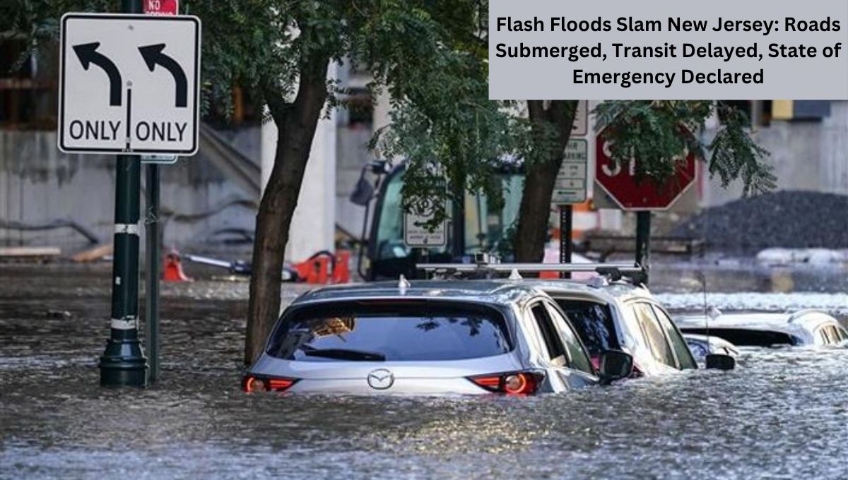
Torrential rain triggered Flash Floods Slam New Jersey: Roads Submerged, Transit Delayed, State of Emergency Declared. On Monday, flash floods across New Jersey overwhelmed cities like Plainfield, Scotch Plains, and New Providence, leaving a trail of submerged vehicles, damaged infrastructure, and massive NJ Transit delays.
With floodwaters rising at alarming rates and more rain forecast, Governor Phil Murphy declared a state of emergency, urging residents to stay indoors and avoid travel. The situation also extended to New York City, where subway lines flooded and over 1,900 flights were canceled nationwide, hitting the East Coast hardest. Meanwhile, social media was flooded with shocking videos of floating cars, waterlogged highways, and desperate rescue efforts.

Flash Floods Slam New Jersey: Roads Submerged, Transit Delayed, State of Emergency Declared
Streets Become Rivers: Flash Floods Slam Plainfield and Scotch Plains
Flash flooding hit Plainfield and Scotch Plains especially hard. Videos posted by locals on X (formerly Twitter) showed Route 22 underwater with stranded vehicles and submerged intersections.
One local wrote, “MAJOR FLOODING underway in Scotch Plains, New Jersey, with cars underwater right now at Park Avenue @ US-22.”
In Plainfield, flash flooding on Greenbrook Road and surrounding side streets knocked out power for over 5,000 PSE&G customers by Monday evening.
The damage comes just weeks after a July 3 storm left three dead in Plainfield, prompting a similar emergency declaration.
NJ Turnpike, I-78, Route 22 Closed Amid Dangerous Flooding
Flash floodwaters inundated major highways, including parts of the NJ Turnpike, I-78, and Route 22, resulting in complete closures and severe travel disruption.
NJ Turnpike toll roads were completely submerged near Exits 12 and 13A, affecting traffic near Linden and Newark.
Videos showed vehicles floating or stranded in high water, especially in New Providence, where the flooding reached street-level storefronts.
The National Weather Service (NWS) reported rainfall rates of up to 2–3 inches per hour, and in some areas, totals exceeded 5 inches, particularly in northern and central New Jersey.
NJ Transit Faces Massive Delays and Service Disruptions
The deluge caused major delays across NJ Transit, affecting rail, bus, and light rail services. Commuters were met with delays of up to 40 minutes between Penn Station New York and Trenton, due to Amtrak signal issues.
Other impacts included:
- North Jersey Coast Line service halted in both directions due to a downed tree near Hazlet.
- Raritan Valley Line service suspended entirely.
- River Line operations stopped between the Walter Rand Transportation Center and the Waterfront Entertainment Center in Camden.
- Substitute bus services rolled out for affected riders.
- Rail tickets were accepted on NJ Transit bus and private carriers systemwide.
Travelers were advised to monitor NJ Transit’s website for real-time updates.
New York City Subways Flooded, Flights Delayed Nationwide
Flash floods in New York City brought similar chaos, with subways flooded, roads submerged, and more than 1,966 flights canceled across the U.S., according to ABC News.
The NYPD Transportation Department warned of delays on the Cross Bronx Expressway, and floodwaters entered gas stations, subway platforms, and even subway carriages.
Queens saw over 1,000 customers lose power, while Staten Island and Chelsea in Manhattan recorded rainfall over 1.5 inches by 7:30 p.m.
The city’s Emergency Management Department urged residents in basement apartments and low-lying areas to prepare for evacuation, keeping go-bags, flashlights, and phones ready.
Full List of Affected New Jersey Counties and Cities
The National Weather Service issued multiple Flash Flood Warnings across New Jersey, targeting dozens of counties and cities:
- Union County: Including Plainfield, Scotch Plains, and New Providence.
- Morris County: Cities like Morristown, East Hanover, and Parsippany faced warnings with 2–4 inches of rainfall.
- Cumberland County: Towns such as Millville, Laurel Lake, and Port Norris saw flash flood warnings into Tuesday.
- Other counties impacted: Bergen, Essex, Hudson, Passaic, Hunterdon, Somerset, and Middlesex.
Union Road in Vineland, I-78, and Route 22 saw multiple vehicle submersions. Numerous local streets across the state were shut down due to rising floodwaters.
Newark Liberty Airport Hit With Ground Stop
Air travelers also faced major disruptions. Newark Liberty International Airport issued a ground stop, halting departures due to extreme weather, with some delays exceeding three hours.
In a post on X, the airport said it expected the ground stop to lift by 9 p.m. Monday, but travelers were urged to confirm their flight status with airlines.
Governor Murphy Declares State of Emergency
As conditions worsened, Governor Phil Murphy declared a state of emergency across New Jersey.
“I am declaring a State of Emergency given flash flooding and high levels of rainfall in parts of the state,” he said on social media.
Murphy urged residents to stay indoors, avoid unnecessary travel, and remain alert for emergency updates.
The National Weather Service warned that additional rainfall was expected through the night, with slow-moving storms continuing to drop rain at rates of 2–4 inches per hour in some areas.
Conspiracy Theories on Cloud Seeding Go Viral
Amid the chaos, social media erupted with conspiracy theories, blaming cloud seeding and geoengineering for the unprecedented rainfall.
Some users suggested chemicals were released into the atmosphere to manipulate weather patterns. Experts quickly debunked these claims.
As reported by The New York Times, similar cloud seeding theories emerged during floods in Texas earlier this month, but no scientific evidence supports these ideas.
“Cloud seeding is highly localized and can’t cause this scale of flooding,” meteorologists confirmed.
Nonetheless, posts claiming “geoengineering is to blame” gained traction on platforms like X, as people searched for answers to the extreme weather.
What’s Next? Weather System Moves South
The NWS has warned that the storm system is shifting south, with North Carolina likely to be next in its path. The public is urged to remain cautious as further heavy rainfall is predicted.
In New Jersey, flood watches remain active through the evening, and emergency crews continue to respond to stranded vehicles, power outages, and blocked roads.
Final Thoughts: A Wake-Up Call for Infrastructure and Preparedness
The flash floods in New Jersey and New York serve as a stark reminder of the growing intensity of weather systems across the U.S. As climate change accelerates and infrastructure struggles to keep up, both state and federal governments may face increasing pressure to modernize drainage systems, improve emergency alerts, and support transit resilience.
For now, New Jersey recovers from a night of chaos. The state’s roads, rails, and skies remain disrupted but hopefully, better prepared for what’s coming next.
Also Read: Trump slammed for ‘hiding on golf course’ as Texas flood death toll rises to 70 and 11 girls missing


